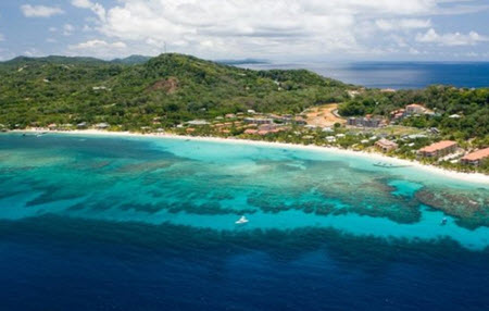
Honduras ( República de Honduras) is a Central American country bordered by Guatemala, El Salvador and Nicaragua. It has a 700 km long Caribbean coastline, extending from the mouth of the Río Motagua in the west to the mouth of the Río Coco in the east. Honduras also has just over 150 km of Pacific Ocean coastline in the Gulf of Fonseca.

honduras
Honduras is a biodiversity hotspot and is – among other things – home to 700 bird species, 110 mammal species and 630 recognized species of orchids. Of the mammals, roughly half of the species are bats. In 1982, the Río Plátano Biosphere Reserve was added to the UNESCO World Heritage Sites List.
The coastal waters of Caribbean Honduras are included in the Mesoamerican Barrier Reef System. Around the Bay Islands, divers can encounter whale sharks, bottlenose dolphins, manta rays and large quantities of colourful reef fish.
Short facts about Honduras
| Name |
República de Honduras |
| Motto |
|
| Anthem | Himno Nacional de Honduras
(National Anthem of Honduras) |
| Official language | Spanish |
| Area | 112,492 square kilometres
(43,433 square miles) |
| Population | 8,25 million (2010 estimate) |
| Capital | Tegucigalpa
(Coordinates: 14°6′N 87°13′W) |
| Currency | Lempira (HNL) |
| Time zone | UTC -6 |
| Calling code | (+) 504 |
| Traffic | Drives on the right |
| Internet TLD | .hn |
Safety
The government of Honduras lacks the capacity to adequately respond to, investigate and prosecute crime and Honduras has one of the world’s highest murder rates. Other violent crimes – such as highway assaults, kidnappings and rape – are also widespread. Due to credible threat information against U.S. Citizens by criminal and drug trafficking organizations, the U.S. Embassy has restricted U.S. Government personnel travel to the department Gracias a Dios in easternmost Nicaragua.
Roatan and the Bay Islands have lower crime rates than mainland Honduras, largely due to measures taken by the government and tourism businesses since 2014.
Geography
 Honduras is characterized by its extensive interior highland area and two narrow coastal lowlands – the Caribbean lowlands in the north and the Pacific lowlands in the southwest. The highland area constitutes roughly 80 percent of the country’s total terrain.
Example of nature types found within Honduras are savannas, mangrove forests, rainforests, cloud forests, pine forests and oak groves.
Honduras includes several populated islands, including the famous Caribbean diving destinations Isla de Roatán and Utila. Roatán, Utila and the island of Guanaja are the three main islands in the archipelago Islas de la Bahía (Bay Islands).
Climate
- The Caribbean lowlands enjoy a tropical wet climate. Temperature and humidity are both high year round, and there is no distinct dry season. Daytime highs average between 28 and 32 degrees C. In December and January, a coldfront can come sweeping down from the north, but only for a few days.The wettest part of the Caribbean lowlands is Mosquitia, where the average yearly rainfall is 2,400 milimeters.
- The Pacific lowlands has a dry season that starts in November and typically continues into May. Daytime high temperatures are high year round, but somewhat higher during the dry season than in the rainy season. April and early May tends to be the hottest part of the year. The humidity increases notable with the onset of the rainy season.
- The interior highlands features a tropical highland climate where temperatures drop as elevation increases. There is a distinct dry season from November to April. Land between 1,000 and 2,000 meters is known as tierra templada (temperate land) while land above 2,000 meters is called tierra fría (cold land). In tierra fría, it is possible for temperatures to fall to near freezing at night and frosts do occur.The capital Tegucigalpa is located at 1,000 above sea level, in a sheltered valley, and enjoys a comparatively mild climate. The warmest month is April, with an average high temperature around 30 degrees C. In January, the coolest month, the average high is approximately 25 degrees C. The average yearly rainfall is 1,000 mm.
Hurricane season
The Caribbean coast of Honduras is vulnerable to hurricanes and tropical storms. In general, the Pacific storms are not as destructive as the Caribbean ones and they are less likely to make landfall.
Notable cities, towns, etc
| City/Town | Population
(2010 estimate) |
Department |
| Tegucigalpa | 1,126,534 | Francisco Morazán |
| San Pedro Sula | 638,259 | Cortés |
| Choloma | 222,828 | Cortés |
| La Ceiba | 174,006 | Atlántida |
| El Progreso | 131,125 | Yoro |
| Choluteca | 93,598 | Choluteca |
| Comayagua | 75,281 | Comayagua |
| Puerto Cortés | 60,751 | Cortés |
| La Lima | 59,030 | Cortés |
| Danlí | 56,968 | El Paraíso |